Tuesday, April 04, 2006
17. Colditz Castle: Tour 1, Exterior, South Side & East Side
We'll circle around the exterior of Colditz castle in a counterclockwise direction from the entry house to the north-east tower in this Part One of our exterior tour.
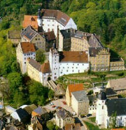
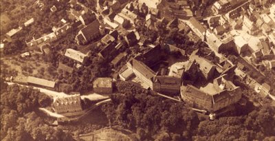
 A. This aerial photo looks to the north-east. The entry house, where we'll start, is the tiny building with the long, narrow, and straight moat bridge angling slightly uphill at about 30 degrees behind and to the left of it.
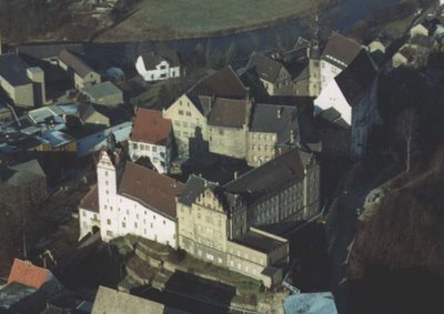
B. This aerial photo looks almost due north. The entry house is just above and to the left of the center-foreground building with the red roof.
C. This aerial photo looks to the north-west-north. The entry house is just above the building in the lower left corner with the red roof.

D. This floor plan is tilted on its side so that south is at the bottom. The entry house is the small open on its right side building at the very bottom.

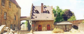
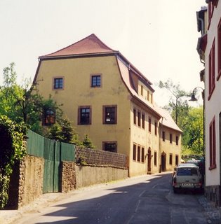
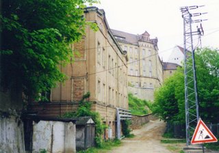
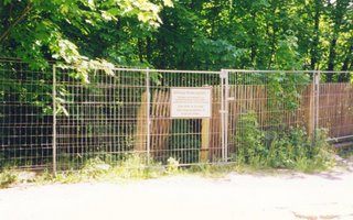
1. Looking north-east up at the entry house on the south end of the castle from a cobble stone street below. That is the entry house with the red sign attached to it, and with the 'vertical' Renaissance decorations on its upper facade.

2. The entry house from its small parking lot just to the south of it. Repairs were under way here and elsewhere on the castle property. The Russians and East Germans allowed the place to deteriorate from 1945 to 1989, as it was felt to be a monument to WWII Allied POW escapes that the Communists certainly didn't want to publicize. I don't recall what the red sign said.

3. Three signs are displayed on the facade of the entry house.
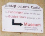
4. This sign guides would-be visitors to the castle to go to the Colditz museum first to pay, get their ticket, and join a guided tour. The English language part reads: "For Guided Tours please go to the Museum".

5. In German and in English this sign tells you a little about Colditz castle as a POW camp (Oflag IV C) from 1939-1945.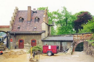
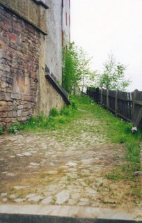
6. Moving to the right now and looking west to start our counterclockwise walk around the outside of the castle, we see the entry house from the east side. To the right of the entry house is the start of the steep moat bridge. Smaller vehicles can enter the castle by this route?

7. This similar view to the one in the photo just above is looking north-west, with the red generator gone and workers putting down cobble stones, shows more of the moat bridge with part of a tour group on its upper end.

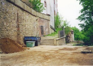
8. A closer view (looking north-west) of the upper end of the moat bridge with the bottom of the now dry moat below. I believe that the moat has been waterless for hundreds and hundreds of years now. If there had been a long-ago drawbridge, it would have been against the front of the castle right at the archway on the right.
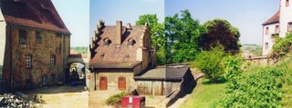
9. and 10. Two quite similar photos looking west show the entry house and some of the building to the left. The lower photo is from further back, and introduces a little of the tiered and vegetation-covered terrace to the right at the moat bridge end. There is that red generator again.
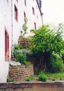
11. Looking east along the south outer facade of the castle. The vegetation-covered tiers of the terrace can be seen in part.

12. Those vegetation-covered tiers of the terrace are clearly visible here, again looking roughly east. The flat-roofed building with the five 'spikes' on top is what I call the (5-windows across) 'cube' building. The building in back on the horizon was the WWII 'married' quarters, so let's just call it that. A lot more will be said about both those buildings, starting with photo 14.

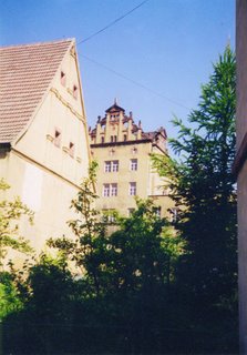
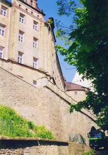
13. Now let's step back and look north up at the south facade of the castle itself. There's that familiar red generator again. And seen behind it the three vegetation-covered tiers of the terrace, and from left to right the main gate house, the tall tower, the rest of the white-painted facade, and the start of the tan building units, the first one 2-windows-across and the second one 4-windows-across.

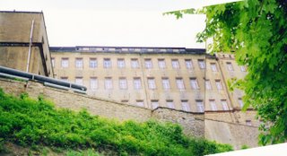
14. Looking roughly north-east here shows the two tan units (the 2-windows-across and the 4-windows-across) and the 5-windows-across 'cube' building with its five 'spikes' on top to the far right.

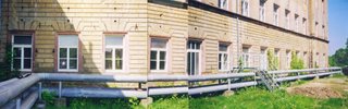
15. Looking east-north-east down again at the east end of the south face where the terrace is more stone than vegetation-covered tiers, we can still barely see the entry house in the distance. We'll talk more about the round stone tower and the two sets of steps on the far right.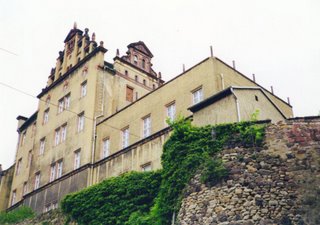
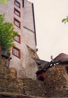
16. Here again (looking roughly north-west) are the tan building units (the 2-windows-across and the 4-windows-across) seen in photo 14, with the 5-windows-across 'cube' building with its five 'spikes' on top to their right, plus a storage shed on top of the round stone tower. This round stone tower is in the very south-east corner of the castle complex. Note the pair of upper facade 'vertical' Renaissance decorations that are so similar to those on the entry house.
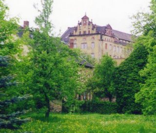
17. and 18. We are looking roughly north-west from a street further to the south for this similar pair of photos taken across lawns. The two photos show the 4-windows-across tan unit with the 'vertical' Renaissance decorations at the facade top.
19. The 5-windows-across 'cube' building with its five 'spikes' on top.
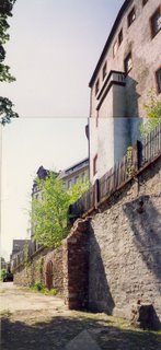
20. We have jumped back up close again, and are looking roughly north-east. Here is that round stone tower seen in photos 14 and 15. The stone steps on the right actually just fit between the round stone tower and the WWII 'married' quarters. There should be a side door into the quarters down that walkway, but I don't know for sure. I didn't walk down there to check. But past it is a awll with at least a 15 foot drop to the level of the wide service road below. Much more on that service road shortly here, when we go around behind the castle to continue our tour.
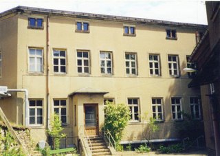
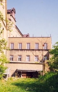
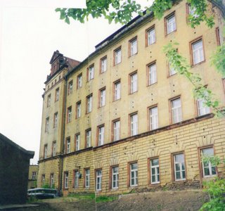
21. Here is the WWII 'married' quarters that almost butts right up against the south-east corner of Colditz castle. These current apartments? are two stories tall on this side, plus their attic and basement windows. We are looking very roughly north-east.
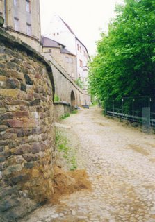
Since we won't be leaping off of that at least 15 foot drop off to get around behind the castle, we'll have to walk around by an indirect route. So we'll turn around, and walk west till we again stand in front of the entry house, and then walk south to the street with the Colditz Museum on it, and walk east up that street to the museum. Let's look at the exterior of the museum as we pass by.

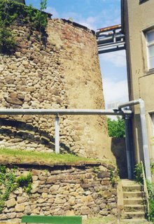
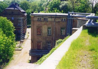
22. and 23. The first of the above photos sees us approaching the Colditz Museum walking uphill roughly to the east. In the second photo we are looking downhill, and back roughly to the north-west.
Afterwards, we can continue east and slightly uphill to a road intersection, and then walk a little further north to the next intersection. Follow the road north for a hundred feet or so, and then turn sharp left (north-west), and follow the wide service road as it leads to the back of the castle.
Colditz castle east side:
E. For orientation purposes for the east side of the castle, this aerial photo is the most helpful. Most everything discussed above is here, but trying to describe where it is would be next to impossible.
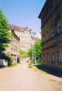
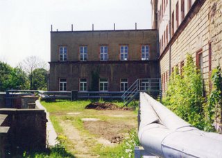
24. Here we are walking north-west up the wide service road toward the back of the castle. We move past the WWII and perhaps earlier stables that are not visible on the left, much of the Terrace House on the right, and the WWII 'married' quarters ahead on the far left. The castle's WWII Kommandantur is on the horizon, with windows #11-#17 of the 17-windows-across south 'face' visible.
The road is starting to curve to the right way up ahead after running straight from the corner behind us. Note that the WWII 'married' quarters are three stories high on this side, plus those attic windows again. This wide service road is much lower than the dead-end alley in front of the vegetation-covered tiered terrace.
25. Here we are walking north-west and moving closer to the castle with the Terrace House now beside us and out of sight on the right. Up ahead the wide service road starts to curve to the right, and head uphill.
26. and 27. Let's pause and look back down (to the south-east, roughly) the straight part and the starting to curve part of the wide service road from a vantage point up on the grass terrace that we haven't reached or talked about yet. That's the Terrace House on the left and the WWII 'married' quarters on the right in the upper photo, and the 'married' quarters and a sliver of the 5-windows-across 'cube' building in the lower photo.
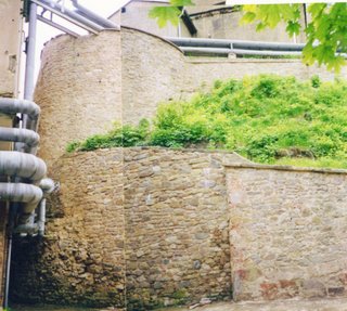

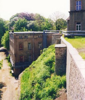
28. and 29. Two photos of what is in the gap between the west end of the WWII 'married' quarters and the 45 degree slope of the castle ramparts that is hidden in photos 23 and 24. Note the at least 15? foot drop off in photo 26 just above. In both the photos you can se the base of that south-east corner tower with its stonework and supporting rampart. We are looking roughly south-east.


30., 31., and 32. Now let's turn around about 180 degrees and face the Park, and look to the north-east. We'll visit the Park later. The path down to the Park, where the POWs got their fresh air, exercised, and escaped, is now blocked off by this gate, and entry is forbidden. The sign tells us as much.

33. and 34. On up the curving wide service road past the round south-east tower rampart base to where you can see the archway that leads into the outer WWII German courtyard. The quarter-round and tan WWII canteen building and the white WWII Dutch quarters building are just staring to come into view. We are looking north-west-north here roughly.
35. Looking up from the wide service road below at part of the two 'faces' of the WWII Kommandantur on the left. There is the 17-windows-across 'face' at the south end, and the 12-windows-across 'face' at the north end. Here we can only clearly see windows #15-#17 of the 17-windows-across south 'face'. That's the back end of a parked blue truck sticking out of the archway. On the right is a glimpse of the WWII Canteen building unit. We are looking roughly north-west-north.

36. Turning around and looking south-east back downhill from just before the archway entry is reached. The WWII 'married' quarters in in the background down where the road has finished curving to the left.
37. Again, looking up from the wide service road below at 15 of the 17-windows-across south 'face' of the WWII Kommandantur building, with a part of the 'cube' building on the far left. We are looking due west.

38. Looking up yet again from the wide service road at the southern end of the WWII Kommandantur 'cube' with its five 'spikes' on top. We are looking south.


39. and 40. These are both the same photo that has been tilted up, then down. Both of course look up from the wide service road below. We are looking roughly north-west. All 12 windows of the 12-windows-across north 'face' show clearly, despite the distortion (ragged roof-line) at the top of these two photos.

41. Here the quarter-round tan WWII Canteen building is seen from below on the wide service road.
42. That is the remains of the north-east corner tower in the background, but more on it later. Right now we will continue walking north, climb those five steps, walk up the short path, and turn 180 degrees and walk south up the path beside that black sloping rail onto the large two roughly triangular grass terraces adjacent to the WWII Kommandantur. We are looking north here.
43. This closeup of the path begins with the top step in the foreground. Beyond the black sloping rail we will be taking, the north bound path just ends abruptly up near the north-east tower. It is currently a 'path to nowhere'. We are looking north.

44. By ascending that 'path to nowhere' a little ways uphill allows us to look back south to where we will be heading up onto the grass terrace adjacent the WWII Kommandantur. So it is up the worn slope, up the eight steps, through the open gate, and out onto the grass terrace. We are looking south. The 'cube' building with its 'spikes' just barely shows. Visible also are windows #1-#5 of the 12-windows-across north 'face'.
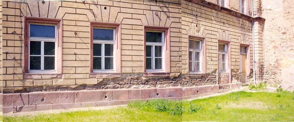
45. Looking roughly north-east back at the gate from the grass terrace we see roughly where Pat Reid's Canteen Tunnel emerged. WWII escape photos are yet to be added.

46. From further out (south) on the grass terrace we look north-east-north and see the WWII Kommandantur on the far left, the quarter-round WWII Canteen building in the middle, the open gate at lawn level, and the WWII Dutch quarters (with its once tunnel-containing) buttress on the right. Visible on the left are windows #9-#12 of the 12-windows-across north 'face'.
47. We are looking south straight at the north side of the 5-windows-across 'cube' building. The bend in the pipes in the right foreground shows where the WWII Kommandantur changes angles to the 12-windows-across north 'face', which is not visible in this photo.
48. Looking north-west at 14 of the windows of the 17-windows-across south 'face' of the WWII Kommandantur. This 'face' of 17 windows includes the two windows in the parallel center section with the 'vertical' Renaissance decorations on top. The sharp bend in the left foreground is where this 17-windows-across 'face' joins the 'cube' building. That the left third of this 'face' appears to 'curve' is just an illusion.
49. This photo shows windows #1-#11 of the 12-windows-across north face of the WWII Kommandantur. This north 'face' also starts with that same 'vertical' Renaissance decoration at the top of the facade. We are looking roughly south with one 'spike' on the 'cube' building just visible between the shed and the WWII Kommandantur.


50. and 51. These matched end to end photos (with just a little overlap) show the 12-windows-across north 'face' of the WWII Kommandantur. We are looking west, more or less.


52. and 53. Let's look back again, this time from a hill (to the north and east) about as high as the premontory Colditz castle was built on, and take a long look at each half of the east facade of the castle. In both photos we are looking roughly west to south-west. In the top photo all 17-windows-across of the south 'face' are visible, plus the first three of the north 'face'. In the bottom photo we see all 12 windows of the 12-windows-across north 'face', plus 14 of the 17-windows-across 'south' face to their left.
 54. We again walk down these 8-steps, down the path, turn right almost 180 degrees and walk down that path, then back down the 5-steps, and turn 180 again to continue north up the service road.

55. As we continue north along the service road we'll see the entry to the winding path through the woods down to the north end of the Park, but we won't take it now or go down to the Park at this time. The WWII POWs did not use this path to the Park.

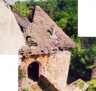
56. Facing back to the left and up from service road we see the facade of the WWII Dutch quarters, with the buttress down through which they started a tunnel. The north-east corner tower is in the right foreground. We are looking north-west here.
57. Looking back due south, and yes, that is the 'cube' building on the far left above the ramparts. That is part of the Dutch quarters with the buttress on the right.

58. Getting close to the NE corner with its damaged tower.
59. More of the damaged north-east corner tower.

60. The north-east corner tower looks to be in better shape here.
61. Plenty of roof detail of the north-east corner tower.
Go to the article titled "Colditz Castle: Tour 2, Exterior, North Side & West Side" to see the rest of the still unfinished tour around the exterior of Colditz castle.
[This topic is still "Under Construction".]

![]()